EnGeoMAP/EnSoMAP toolboxes
Instructor: GFZ Potsdam, TBD (Robert Milewski, Saeid Asadzadeh, Helge Dämpfling)
Time: 2 hours
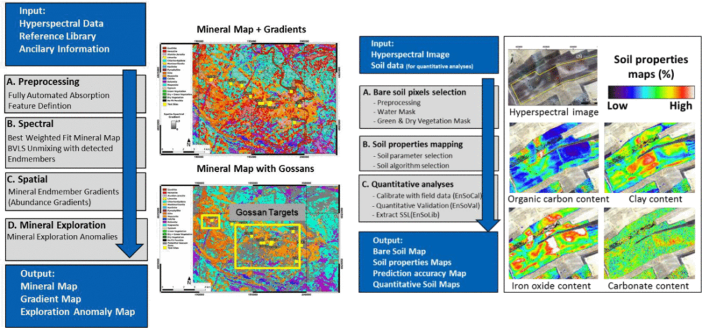
Tutorial description: This tutorial covers the use of the EnMAP Geological Mapper for Mineral Classification (EnGeoMAP) and EnMAP Soil Mapper (EnSoMAP) toolboxes, which provide easy to use workflows for the analysis of hyperspectral VNIR-SWIR remote sensing data (such as EnMAP data). Both toolboxes are part of the EnMAP-Box QGIS plug-in for geological (EnGeoMAP) and soil applications (EnSoMAP) respectively.
The EnSoMAP toolbox allows fully automatic generation of semi-quantitative soil maps for soil moisture, soil organic matter, iron oxide, clay, and carbonate content, and includes quantitative soil mapping tools. EnSoMAP provides users with a suite of tools that can be used for soil applications by incorporating hyperspectral algorithms with an easy-to-use graphical interface based on simple menu-driven functions. It further includes a soil mask option to remove water, green and dry vegetation pixels based on spectral indexes. In order to create semi-quantitative soil maps based on analytical and empirical algorithms no user input data (e.g., spectral libraries, ground truth data) is needed. For more experienced users there are additional tools that allow for a fully quantitative soil mapping. EnSoMAP offers the choice of multiple algorithms for each soil parameter. The EnGeoMAP is an expert-system-based tool for the processing and characterization of geologic surface cover types from hyperspectral data in general and EnMAP satellite data in particular. EnGeoMAP uses the characteristic spectral absorption features of materials for their classification.
Prerequisites: Participants need to bring their own laptops with the latest versions of QGIS and the EnMAP-Box plug-in preinstalled. See instructions here for detailed installation and make sure all additional python packages are installed correctly.